

April 28, 2023 1:00 pm
In this quarterly Research Seminar, Ali Ebrahimian, Ph.D., Principal Investigator; and Nasim Mohamadiazar, Ph.D. student, present work under the ABC-UTC research project entitled , Integrated Flood and Socio-Environmental Risk Analysis for Prioritizing ABC Activities [ABC-UTC-2016-C4-FIU04], conducted at Florida International University in Miami (FIU)
Documents:
Integrated Flood and Socio-Environmental Risk Analysis for Prioritizing ABC Activities - pdf of presentation
Q&A Session - pdf (to be posted soon!)
Description: The need to accelerated bridge construction (ABC) activities due to flooding has complex interdependencies with many physical, social, and environmental factors in urban areas. Flood-related factors can also contribute to bridge scour, the biggest cause of bridge failure in the United States. This Seminar presents a GIS-based, multi-criteria decision analysis framework to assess the vulnerability of urban areas against flooding and socio-environmental factors and risk of bridges considering structural and traffic conditions. The final product is a risk map that shows an overall risk factor for each bridge. Application of the framework will be demonstrated for existing bridges in Miami-Dade County, Florida. The proposed framework is systematic, structured, and flexible, making it adjustable to be implemented in different geographic locations. Hence, it can be used by state DOTs as a practical, risk-based decision support tool for prioritizing bridge rehabilitation activities based upon technical, social equity, and environmental justice criteria in the presence of limited budgets.
Presenters:

Ali Ebrahimian, Ph.D.
Assistant Professor
Department of Civil and Environmental Engineering
College of Engineering and Computing
Florida International University
Email: alebrahi@fiu.edu

Nasim Mohamadiazar, Ph.D. Student
(Ph.D., Fall 2024, FIU)
Department of Civil and Environmental Engineering
College of Engineering and Computing
Florida International University
Email: nmoha031@fiu.edu
Presentation Graphics:
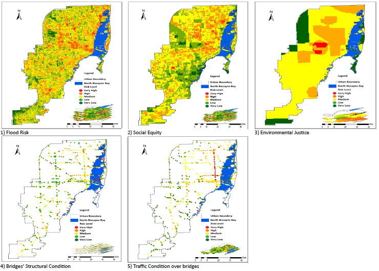
Figure 1. Integrated vulnerability maps for the study area (urban areas of Miami-Dade County, Florida). Top row (Left to Right): Flood vulnerable areas, Socially vulnerable areas, and Environmentally vulnerable areas. Bottom row (Left to Right): Structural vulnerability of bridges, and Traffic vulnerability of bridges

Figure 2. Integrated risk maps demonstrating overall risk factors for each bridge in the study area. Left to Right: Scenario-1: only using structural and traffic criteria; Scenario-2: only using structural, traffic, and flood criteria; and Scenario-3: using structural, traffic, flood, social equity, and environmental justice criteria