

Link to Latest Report: Coming Soon
Background:
For low-lying coastal communities, hurricane-induced hazards, especially storm surge, often represent the greatest threat. Major hurricanes result in large casualties, enormous property damage, and severe socio-economic disruption. Lifeline infrastructure systems, including bridge and roadway networks, are not immune to such devastating consequences of hurricanes. The diminished functionality of bridge and roadway networks, as a result of wind and water damage, directly impedes the entire hurricane recovery process. The essential role of bridge and roadway networks in hurricane response is evident: the distribution of disaster supplies from federal and state emergency management agencies depends on functioning roadways and bridges; affected residents also need reliable transportation to access essential services, such as healthcare, grocery, and employment. Therefore, it is widely recognized that effective planning for bridge and roadway network restoration and associated resource allocation to different regions is a critical task to ensure a rapid recovery of coastal communities in the aftermath of hurricanes. The primary goal is to develop a tool to evaluate community resilience in terms of the ability to access critical services following hurricanes and provide a decision-making framework to integrate equity into bridge and road networks restoration activities after hurricanes.
The post-hurricane recovery of bridge and road infrastructure networks is crucial for the recovery of other systems within communities. Substantial research has been conducted to advance related literature, including various optimization methods for selecting, sequencing, and scheduling roadway repair projects while accounting for material and human resource constraints. However, a significant research gap remains in the consideration of equity across different population groups or geographical regions. It is increasingly important to ensure all residents have comparable access to essential services and resources during hurricane recovery, regardless of socio-economic status. Recent studies have highlighted the inequitable government response to natural disasters, with underserved communities receiving less support, experiencing greater impacts, and taking longer to recover. This issue is especially important in South Florida’s most populated metropolitan area, where coastal communities are highly vulnerable to hurricane threats. Urgent research efforts are needed to ensure that bridge and road infrastructure network restoration can be conducted rapidly and equitably.
Objectives:
The primary goal is to develop a tool to evaluate community resilience in terms of the ability to access critical services following hurricanes and provide a decision-making framework to integrate equity into road network restoration activities after hurricanes. The specific objectives include: (1) to develop a flooding map to identify vulnerable roads and bridges; (2) to develop an effective optimization model by integrating equity in the restoration stage of the coastal bridge and roadway networks; (3) to develop multisector stakeholder collaborations to provide optimal recovery sequences.
Scope:
The project’s research tasks have been developed to meet both the overarching goal and specific objectives of the project.
Task 1 – Development of a 2D Flooding Map for Bridges and Roadway Networks
In this task, the FEMA historical data will be used to generate 2D flooding maps to determine the roadway segments that may flood by; and how high floodwaters may get. The 2D flooding inundation map could be developed by the following steps:
- Identify the study area and define the scope of the mapping project.
- Collect data on the transportation network, including road and bridge locations, elevations, and characteristics.
- Obtain data on the natural features of the area, such as rivers, lakes, and floodplains, which can potentially impact the transportation network.
- Gather historical data on previous flooding events and their impacts on the transportation network.
- Use GIS software to integrate the transportation network data and the natural features data to develop a base map.
- Overlay the historical flood data on the base map to identify areas that are prone to flooding and to determine the severity and frequency of flooding in the study area.
- Analyze the collected data to identify vulnerable sections of the transportation network and to determine the potential impacts of flooding on transportation.
- Develop a flooding map for bridges and roads, highlighting vulnerable areas.
Task 2 – Quantification of Equity for Roadway Networks After Hurricanes
A number of studies have examined both individual-level risk factors and community-level drivers associated with spatial patterns in local transmission for COVID-19 (Andersen et al, 2021). Further, recent research has studied the potential access to health care (e.g., access to ICU beds) both in terms of the accessibility differences between population sub-groups and in terms of differential access among geographic locations (Cromley and Lin, 2022).
This task will investigate new methodologies to accurately assess the equity in transportation network accessibility of populations. A network topology-based resilience measure will be used to assess transportation system performance and assess accessibility to health care resources in the aftermath of hurricane-pandemics. A network connectivity metric that considers attributes such as in-vehicle time, waiting time and service reliability will be used to quantify equity (Kaplan et al., 2014). Other well-known metrics, such as Gini coefficients (De Maio, 2007), will also be considered to express the overall degree of inequality of transit provision. To assess the vulnerability of populations due to lack of access to health care and essential services this task will develop spatial analytical models of demographic characteristics such as prevalence of obesity and heart disease in a population. In particular, a geographically weighted regression (GWR) model will be employed to quantify the spatial distribution of the key demographic variables at various geographic scales (tract, block group) and its relation to the access to transportation facilities (Nicholson et al., 2019). To quantify the temporal relation between COVID-19 infection counts on these demographic variables and understand the drivers of population vulnerability related to transportation access a hierarchical/multilevel regression models (Gelman and Hill, 2006) will be built.
Task 3 –Integration of Equity in Restoration Planning for Roadway Networks
Efficient operation of a transportation system is particularly important in alleviating the impacts of disruptive events, and the repair and reconstruction of transportation infrastructure consumes tremendous material and human power. In particular, under disruptive disasters, which lead to capacity degradation of transportation infrastructure, it is particularly important to devise an equitable restoration plan that minimizes the aftermath impacts during the recovery period.
This task will focus on equity in the restoration stage of a transportation system to provide effective decision-making methodologies. Equitable task restoration is considered as one important aspect of resiliency for transportation systems. In order to ensure equitability of restoration, the proposed research will use a two-stage optimization framework. The first stage optimization takes the total travel time as the objective function to solve for the decision on which road sections of the network will be repaired after the event given a limited budget. In the second stage, the objective function is the unmet demand and the optimization solves for the decision is made to determine if increased capacity is needed on any link. Unmet demand has been proposed as one measure of resilience for freight transportation, it has not been used for equitable transportation systems. To determine the unmet demand, we will incorporate the vulnerability profiles developed in task 1. The temporal vulnerability profiles will be used as weights in the connectivity network to formulate the restoration planning optimization. For example, the sub-populations with large proportion of disabilities will receive higher priority to restore public transportation links, while the sub-regions with chronic diseases such as obesity and heart disease will receive higher priority to restore links to urgent care and hospital facilities. The Bureau of Public Roads function will be adopted as the travel time function in this work (Maerivoet and De Moor, 2000) when data is not available.
Task 4 – Multisector Stakeholder Collaboration and Engagement in BRIN Restoration planning
Multisector stakeholders, including government agencies, private sectors, nongovernmental organizations, academic institutions, and community residents, will be involved in the process of transportation network recovery planning, as can be seen from Figure 2. The social structure of the network and the positions of the stakeholders will be described by the network centrality measure, including degree centrality, eigenvector centrality, and betweenness centrality. This tool will help facilitate more effective and collaborative transportation network restoration planning to provide risk- and resilience-informed decisions.
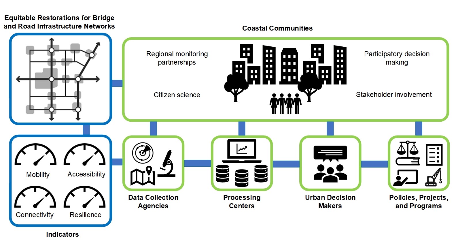 Fig. 2. Multisector Stakeholder Collaborations and Engagements
In this task, social network analysis (SNA) would be used to analyze how multisector stakeholders collaborate and contribute to Bridge and Road Infrastructure Networks Restoration planning. SNA investigates the patterns of social relationships and interactions among actors in a bounded social system, and it is used to address the following research questions:
- Which sector of stakeholders is the most influential (or the least influential) in Bridge and Road Infrastructure Networks Restoration planning processes?
- Are there significant differences across different stakeholder sectors in contributing to Bridge and Road Infrastructure Networks Restoration planning?
- Is the multisector stakeholder collaboration system centralized or decentralized in Bridge and Road Infrastructure Networks Restoration planning?
- What forms of stakeholder collaboration (e.g., intrasector collaboration or intersector collaboration) are more dominant in Bridge and Road Infrastructure Networks Restoration planning?
Task 5 – Final Report and corresponding documentation
The task involves creating the Final Report, and corresponding documentation. The final report will document the research outcomes, including the pilot study results, the software for the proposed framework and its user manual. All principal investigators and students involved in the project will contribute to producing the final report and deliverables. Additionally, the framework will be made open-source, enabling continuous improvement and development by the scientific community.
Research Team:
Principal Investigator: Qianwen Guo